Focus sites of the CoP
Focus sites of the CoP
These focus sites are one type of member within the Community of Practice, illustrating how diverse stewardship models sustain biodiversity and livelihoods over time in complex socio-ecological systems.
We are currently recruiting new sites in other geographical regions.
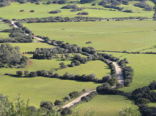
Land stewardship for the conservation of an agroecological mosaic “Custòdia Agrària”
Location: Minorca (Balearic Islands), Spain
Category: Pilot site

Land stewardship for the conservation of an agroecological mosaic “Custòdia Agrària”
Location: Minorca (Balearic Islands), Spain
Category: Pilot site
Thriving Biodiversity
Minorca is characterized by a diverse mosaic of terrestrial and coastal ecosystems, including wetlands and traditional agroecosystems shaped by centuries of farming. The close mix of cultivated fields with natural and semi-natural habitats, along with an extensive network of dry-stone walls, creates a structurally complex landscape that provides shelter, resources, and pathways for a wide range of plant and animal species.
About
Established in 2004, this model has contributed to the conservation of Minorca’s mosaic landscape and promoted environmentally and economically sustainable farming. Today, around 12% of Minorcan farms are part of the Land Stewardship network and 4% of Minorca’s total land area is under stewardship agreement.
The farmers themselves, together with the NGO GOB, act as stewards of the model. The model is based on voluntary agreements between farmers, landowners, and GOB, fostering collaboration for long-term sustainability. GOB supports farmers in strengthening resilience, both in their agricultural practices and in environmental and economic terms. The NGO also monitors environmental impacts such as ecological footprint, alongside bioindicators of ecosystem health and carbon capture. Expanding the model to new farms and raising awareness through education are also central to GOB’s work.
Demonstrated Impact
The model enhances biodiversity and strengthens farmer income. Products from Land Stewardship farms show much lower ecological impacts: beef has a 60% smaller footprint, fruits and vegetables 66% less, and cured meats 71% less than the Spanish average, thanks to extensive grazing, fewer agrochemicals, and reduced external feed.
Monitoring
From 2009 to 2025, OBSAM carried out comprehensive biodiversity surveys covering 47 farms and 4,265 ha (about 6% of the island), resulting in yearly reports, scientific publications, and detailed ecological cartography.
Partners
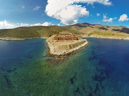
Fishing no-take zone in MPA
Location: Gyaros (Cyclades), Greece
Category: Pilot site

Fishing no-take zone in MPA
Location: Gyaros (Cyclades), Greece
Category: Pilot site
Thriving Biodiversity
Unique for its lush extend of Posidonia meadows, little impacted deep coral formations and for holding one of the largest population of Mediterranean monk seal, Gyaros also boosts, in its terrestrial part, a rich endemic plant life and thriving seabird colonies.
About
Since 2013, this model is supporting habitat protection and biodiversity conservation and the recovery of fish stocks affected by fishing pressure. By reducing illegal activities within the MPA, it also aims to enhance catches in the surrounding fishing areas, adjacent to its 26,000 hectare No-Take Zone (NTZ). The model also seeks to increase knowledge, enhance stakeholder awareness and engagement and to preserve social and cultural aspects.
The MPA is supported by WWF Greece and is under the responsibility of the Greek Natural Environment and Climate Change Agency (NECCA). Key to the initial success of the management scheme was the establishment of a co-management committee comprised of representatives from ministries, local authorities, fishers and other area users, NGOs, and research bodies.
The model manages human activities, especially fisheries, through a no-take zone supported by a remote surveillance system, regulation of maritime uses and anchoring control. It also focuses on monitoring the area’s natural environment and raising awareness among various stakeholders.
Demonstrated Impact
The model has contributed to significant biodiversity recovery, knowledge increase and habitat protection. It also led to a major reduction in illegal fishing activities (85% in illegal professional fishery) and is positively perceived by most of the local fishers (78%).
Monitoring
Between 2018 and 2023, HCMR has conducted experimental fishing surveys inside the MPA (37 visits and over 120 hauls), resulting in a thorough understanding of the area’s marine life and documenting a significant recovery of local fish populations.
Partners
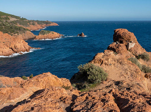
Fishing no-take zone established by small scale fishers
Location: Cap Roux (Provence), France
Category: Pilot site

Fishing no-take zone established by small scale fishers
Location: Cap Roux (Provence), France
Category: Pilot site
Thriving Biodiversity
Cap Roux is characterized by rocky seabeds, Posidonia seagrass beds, and coralligenous reefs, which allow a wide variety of fish to live, feed, and reproduce.
About
Established in 2003, the Cap Roux fishing reserve model aims to preserve fish stocks to support artisanal fishing and protect marine habitats. The reserve was created by the Prud’homie of Saint-Raphaël, a traditional governance institution dating back to 1856 and bringing together 18 fishers. Other stakeholders are also involved, such as the city of Saint-Raphaël, the Estérel Côte d'Azur urban community and various NGOs.
Within the 445-hectare protected zone, all forms of fishing are prohibited. The prud'homie fishers carry out experimental fishing to assess fish stocks.
The Prud’homie of Saint Raphaël seeks to strengthen the coordination and communication between fishers, scientists, and local authorities to maintain the effectiveness of the fishing reserve and continue showcasing Cap Roux as a model of positive, locally driven marine conservation.
Demonstrated Impact
This model has led to an increase in overall fish biomass and in the size of individual fish caught. It has also contributed to the export of juvenile fish outside the fishing reserve.
Monitoring
Since 2003, the University of Nice (Ecoseas Laboratory, previously known as Ecomers) has led monitoring activities in the no-take zone in collaboration with local fishers. Now the community aims to enhance data collection and ensure coherent, collaborative monitoring of the fishing reserve.
Partners
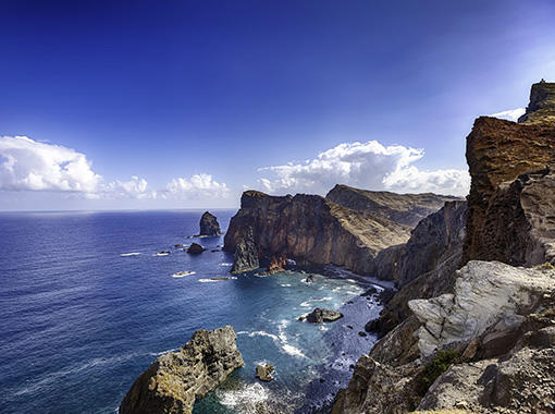
Community-led management of marine resources “Conscious sustainable fishing”
Location: El Hierro (Canary Islands), Spain
Category: Pilot site

Community-led management of marine resources “Conscious sustainable fishing”
Location: El Hierro (Canary Islands), Spain
Category: Pilot site
Thriving Biodiversity
El Hierro is characterized by a very narrow continental shelf, oligotrophic waters, and fragile marine ecosystems. The island’s marine landscape, of an eminently volcanic nature, creates a wide variety of environments that support a rich and diverse flora and fauna, well preserved thanks to the absence of mass tourism and decades of fisheries management focused on environmental, social, and economic sustainability.
About
Since 1978, this model has promoted the protection of marine ecosystems while fostering economic, social, and environmental sustainability. Forty small-scale fishers, acting as stewards, are organized in a representative, consultative, and collaborative body known as the “Cofradía”, a governance model dating back to the 16th century. Through collective decision-making, El Hierro’s fishers manage marine resources sustainably, participate in fisheries monitoring with the scientific community, and implement self-regulation practices to protect both the resources and the seabeds they work on. Notable measures include eliminating high-impact fishing gear and creating the “Punta de La Restinga–Mar de Las Calmas” Marine Reserve of Fishing Interest, as well as other agreements driven by the local fishing sector itself, such as increasing minimum catch sizes and establishing voluntary fishing closures.
Demonstrated Impact
This model has enabled the conservation of marine resources and the preservation of the fishers’ cultural identity and cohesion while contributing to the stabilization of economic income that supports the viability of their fishing activities.
Monitoring
For over 40 years, the University of La Laguna, the Spanish Institute of Oceanography (IEO) and Pescaviable have empowered small-scale fishers in El Hierro with scientific insight, socio-economic support, marine-reserve planning, and practical management guidance.
Partners
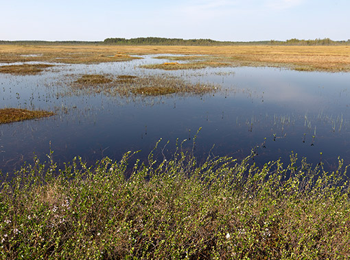
NGO supported traditional management by local communities
Location: Valkeasuo (North Karelia), Finland
Category: Pilot site
NGO supported traditional management by local communities
Location: Valkeasuo (North Karelia), Finland
Category: Pilot site
Thriving Biodiversity
Valkeasuo is a largely intact boreal peatland and forest mosaic that supports exceptionally rich biodiversity, including the region’s best nesting sites for bean geese, endangered golden eagles, other migratory birds, especially waders like godwits and is visited by large predators such as wolverine, lynx, wolf and brown bear. Valkeasuo’s mostly pristine condition and strong restoration potential make it a critical stronghold for thriving boreal ecosystems.
About
Located in the Koitajoki Basin, Valkeasuo has benefited from its proximity to the Koivusuo Strict Nature Reserve, an IUCN-protected area since 1982, as well as other nearby protected areas, helping to preserve biodiversity. Considered unsuitable for forestry use and located close to the reserve, the site remained largely undisturbed for decades despite lacking formal protection. About two-thirds of Valkeasuo remains pristine, while the remaining area has strong restoration potential. Valkeasuo also plays an important role as a headwaters ecosystem for streams and for the Kelsimä River, a major subcatchment of the Koitajoki system. For two years, Snowchange has owned a 450-hectare area at the heart of Valkeasuo where all economic exploitation is prohibited. By integrating local knowledge, community participation, and strict ecological protection, the model supports peatland restoration, intact ecosystems, and traditional practices such as berry harvesting. Restoration activities include restoring hydrological cycles, closing forestry ditches and identifying restoration potential for nutrient-rich letto peatlands present at the site. Valkeasuo represents an alternative to top-down and extractive land use, demonstrating that conservation can coexist with sustainable livelihoods and the long-term protection of natural and cultural values.
Demonstrated Impact
Through management agreements and the inclusion of local people, Snowchange was able to extend Valkeasuo’s conservation influence to an additional 150 ha, bringing the total area under the model’s influence to 600 ha. Collaborations with neighbouring landowners, including the Finnish state and Tornator forestry company, have secured buffer zones and safeguarded valuable peatland area.
Monitoring
Monitoring in Valkeasuo combines long-term scientific data, including hydrological monitoring (aquatic indicators), remote sensing, habitat classification, greenhouse gas fluxes and assessments, as well as species records, through government research and Snowchange’s traditional knowledge–based ecological baselines.
Partners
Explore the project
These focus sites sit within a broader collaborative project, linking local stewardship, research, and conservation practice.